General geology

Fossil Friday - bourbon and geology

2011-02-20a

2011-02-20a

2011-02-20b

2011-02-20b

2011-02-20c

2011-02-20c

2011-02-20d

2011-02-20d

2011-02-20e

2011-02-20e

2011-02-20f

2011-02-20f

2011-02-20g

2011-02-20g

2011-02-20h

2011-02-20h

2011-02-20i

2011-02-20i

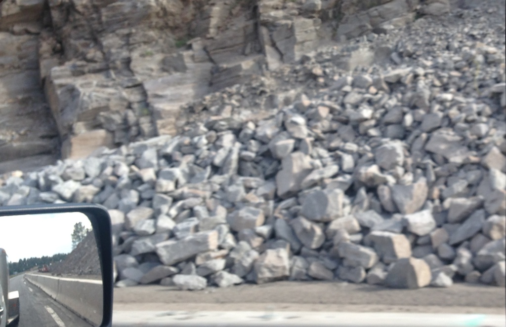
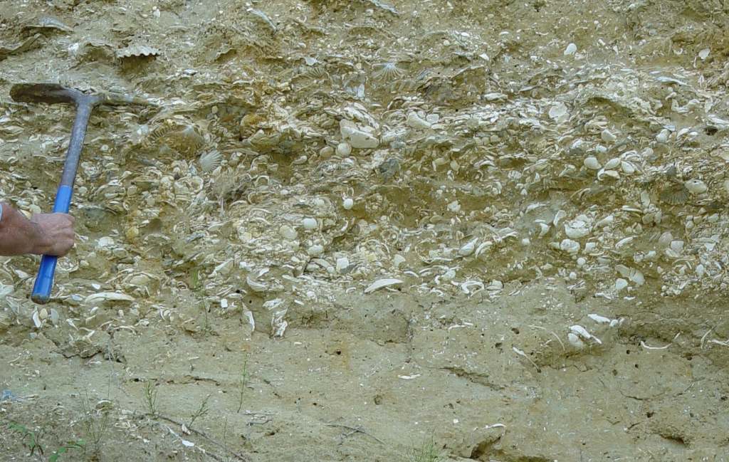
In a few weeks we'll be opening our new exhibit at WSC, "Life in the Ancient Seas", which will include a fair number of specimens from Ordovician rocks in the midwest. In recognition of that event, I'm reposting this post, originally published on my old blog "Updates from the Paleontology Lab" in 2011.A signature product of the southeastern United States, and one with which my family has had a generations-long relationship (at least as consumers), is bourbon whiskey. Bourbon is produced through a rather complex process involving the fermentation of corn and grain, which is then double- or triple-distilled and finally aged in charred white oak barrels; the general guidelines defining bourbon are actually formalized in U. S. law. Approximately 90% of all the bourbon produced in the U.S. comes from the Bluegrass region of northern Kentucky, so Brett and I spent the weekend there with our friends Andy and Shannon exploring the Bourbon Trail, visiting six distilleries in two days (Makers Mark Distillery’s aging warehouse shown above). But what makes this region so good for producing bourbon?It’s all in the water. Bourbon production is a water-intensive process, with water figuring heavily in every stage of production (Fryar, 2009). A steady supply of low-temperature water is important for the distilling process, and in early (pre-refrigeration) days that meant natural springs. It helps the fermentation process if the water has a somewhat high pH, as bacteria involved in fermentation respond well to these conditions. A high iron content in the water is bad, as it adversely affects both color and taste. But this simply moves our question back another step; why does northern Kentucky have water with these characteristics?To answer that, we have to go back to the Ordovician. The Inner Bluegrass region is underlain mainly by lower and middle Ordovician rocks, while the Outer Bluegrass region is mostly underlain by late Ordovician and Silurian rocks (as shown on this Google Earth/USGS map overlay):During the Ordovician Kentucky sat in the tropics, and this area was part of a vast carbonate platform covered by a shallow inland sea. The evidence can be seen in every roadcut in the area (such as the one shown above, south of Lexington), in the form of huge numbers of marine invertebrate fossils. The fauna is dominated by brachiopods and bryozoans, with large numbers or rugose and tabulate corals, crinoids, trilobites, mollusks, and a variety of less common critters:The rocks containing these fossils are almost entirely limestone, mostly made of fragments of the shells. This limestone is very porous, and like all limestones is composed primarily of carbonate minerals, especially calcite (CaCO3). Calcite is quite soluble, especially in acidic water, and limestone areas are often riddled with caves and sinkholes, known to geologists as karst topography. The surface expression of karst topography is clear on topographic maps in the form of numerous ponds and depressions, as in this region just east of Bardstown (USGS Bardstown 7.5’ Quadrangle):Karst topography results in lots of groundwater flow, producing the springs and natural wells needed to provide a reliable, constant-temperature water supply.High dissolved carbonate concentrations also raise the pH of water (i.e. make it less acidic). As mentioned above, this is good for fermentation, which is the first step in bourbon production, as seen in the fermentation vats at Four Roses Distillery:Iron is not a component of the shells of marine organisms, so under ideal conditions carbonates should be poor in iron. However, clastic sediments derived from erosion on continents are iron-rich. Since carbonates are usually deposited in fairly shallow water, there is usually a nearby source of terrestrial sediment, so the limestones often have a fairly large amount of iron. But the Ordovician carbonate platform of which Kentucky was a part was vast, fully 500 miles across. In the earliest Ordovician the coast of North America was a passive margin, so with sea level high there was little or no dry land anywhere near Kentucky (map from Ron Blakey’s Paleogeography and Geologic Evolution of North America website).By the late Ordovician, subduction off the coast of proto-North America had resulted in the formation of arc volcanoes. With no significant terrestrial plants, erosion of these mountains was rapid, and they began dumping lots of iron-rich sediment initially into the Appalachian Trough, and eventually onto the carbonate platform. But all this was happening several hundred miles from Kentucky, so even by the end of the Ordovician and into the Silurian there was still no significant terrestrial sediment being deposited in the Bluegrass region (again, map from Ron Blakey’s Paleogeography and Geologic Evolution of North America website):As European settlers moved west over the Appalachians, the Bluegrass region of Kentucky was the first place these rocks were encountered. While Ordovician limestones are common to the north and west of the Bluegrass region, a larger percentage of clastic sediments results in a higher iron content in the groundwater. The unique conditions experienced by the Bluegrass region 450 million years ago resulted in the deposition of thick sections of relatively iron-free limestones, providing the abundant, clean groundwater needed for bourbon production.Reference: Fryar, A. E., 2009. Springs and the origin of bourbon. Groundwater 47:605-610.

Fossils of my youth

Inspired by the #GatewayFossil hashtag on Twitter, I'm reposting this piece that I originally published at "Updates from the Paleontology Lab" on June 9, 2009.My first exposure to fossils in the field (as opposed to in a museum) occurred when I was around 5 years old.When my father was a teenager he used to hunt with my grandfather in the mountains along the Botetourt-Craig County line in western Virginia, where he had casually noticed some fossils in the stream gravels (I’m not sure he knew at the time what they were). My mother has always had an interest in rocks and fossils (due to the influence of her grandfather), so my dad used to take us up to that area to look for fossils. We mostly found molds of crinoid column segments and occasional brachiopods in a brown sandstone (above). With the limited resources available to a relatively poor child growing up in the country at that time (no internet!), I didn’t know much more about those fossils, and doing my college work in Minnesota and Louisiana I never actually learned much about the rocks I collected in my youth, a point that was emphasized with the discovery last year of the Boxley stromatolite in Bedford County (where I grew up).Now that I’m back in Virginia with years of geologic training behind me I can look at these rocks in a new light. Last Friday, my father and I spent the day driving around Botetourt and Craig Counties, looking at rocks. Near Webster, VA we stopped at a railroad trestle close to the Blue Ridge Fault, with deformed Cambrian Rome Formation exposed in the trestle foundation:The concrete used to build the foundation also had large chunks of Conococheague Formation embedded in it (this bridge is only a couple of miles from the Boxley Blue Ridge Quarry):Moving into Craig County, we followed Stone Coal Road into the mountains (although I’m using the term “road” in its broadest sense):We came across several roadcuts of interbedded shales and fine-grained sandstones:These rocks are from the Devonian Chemung Formation (apparently redescribed as the Foreknobs Formation). They are tilted nearly 90 degrees, which is especially clear where the rocks intersect with the road (the lines leading toward the truck):In a few places the Chemung was rippled:And eventually we found some examples of the fossil crinoid and brachiopod molds that are common in this unit:Returning to my father’s house in Botetourt County I took a look at the rocks exposed under his house and storage shed. The exposures are pretty limited:Even so, there were some interesting bits, including this contact between a cross-bedded sandstone and a limestone:According to the Geologic Map of Virginia the mountain where Dad’s house is located includes both the Rome and Elbrook Formations (both Cambrian); I think this rock may expose the contact between them (with the Elbrook being the lighter-colored limestone at the top).

Capitan Reef Complex

DSCN4446As Brett and I headed east over the weekend on our way to collect mastodon data, we made a few detours to examine geologic features and collect fossils for the museum.At a roadcut just east of El Paso, Texas (above) we spent 30 minutes examining and collecting small fossils:IMG_3882Notice the oblong dark splotches above the scale bar, that are just a few millimeters long. Here's a closeup of one of them:IMG_3889These fossils may be tiny, but they're actually giants within their group. These are shells (or "tests") from fusilinids, a type of foraminifer. Foraminifera are protists, so these are shells from single-celled organisms!Fusilinid foraminifera first show up in the fossil record during the Silurian Period, but they reached their heyday during the Permian Period, when they were present in vast numbers in shallow marine waters; the rocks in this area are Permian rocks. The fusilinid party wouldn't last, however. After surviving more than 150 million years, the entire fusilinid line went extinct at the end of the Permian Period during the huge Permo-Triassic mass extinction when 90% of the species on Earth were wiped out.Continuing east, this imposing structure rose up out of the desert in front of us:DSCN4449This is the southern end of the Guadalupe Mountains, with a huge limestone cliff called "El Capitan" forming the summit:DSCN4621(See a Gigapan we shot of El Capitan here.)El Capitan is part of Guadalupe Mountains National Park, so accompanied by Max we made a brief stop at the visitors center:IMG_3917El Capitan is the namesake of a feature known as the Capitan Reef Complex, a huge Permian barrier reef which is formed in part by the Guadalupe Mountains (Carlsbad Caverns in New Mexico is also part of the reef), and which surrounds a depression called the Delaware Basin. This reef system was made up largely of algal mounds called stromatolites and oncolites, such as the ones below (all the closeup images below are specimens on display at the park visitor center):IMG_3896Sponges were also major contributors to the reef system:IMG_3907As with most reefs, there was a vast array of other organisms living on the reef, including brachiopods:IMG_3906...crinoids:IMG_3898...bryozoans:IMG_3905...and bivalves:IMG_3902...as well as rugose corals, fusilinids, cephalopods, fish, and other animals.So how did this reef end up in Texas? The origin of the reef is tied in tightly with plate tectonics. In the period immediately before the Permian, the Pennsylvanian Period, a major continental collision began to take place between Gondwana (a continent made up in part of what is today South America, Africa, Australia, Antarctica, and India) and Laurasia (which today forms North America, Europe, and most of Asia). At the end of the Pennsylvanian Period and the beginning of the Permian Period, the Gondwana-Laurasia collision formed the Ouachita and Appalachian Mountains. A large mountain range such as the Ouachitas is so heavy that it pushes down the surrounding continent, forming a low area called a foreland basin. This basin can be hundred or even thousands of meters deep, and if it connects to the ocean it will fill with sea water. The Persian Gulf is a modern example of such a basin. Below is a map from Ron Blakey showing the North American part of Laurasia during the middle Permian (link to the original map):namP275And below is a version I've marked up with the locations of the collision, the foreland basin, and the Capitan Reef Complex:Permian mapOutside the reef are extensive shallow marine sediments, often with fusilinids and other marine fossils, such as the ones we examined near El Paso. Inside the reef, water flow is restricted and evaporation rates are high. This results in the deposition of salt, gypsum, and other minerals that dissolve in seawater, leaving evaporite deposits:IMG_3290Since foreland basins always have a mountain range nearby (which is what causes them to form in the first place), they rapidly fill with sediment eroded from the mountains and with limestone produced by marine organisms and evaporites precipitated from seawater. By the end of the Permian Period the Delaware Basin had filled with sediment more or less to the top of the Capitan Reef, and the reef was exposed as dry land. It partially eroded and the remnants were buried, but about 200 million years later another tectonic event, the Laramie Orogeny, formed faults that brought part of the reef, including the Guadalupe Mountains, back to the surface. Subsequent erosion removed many of the softer evaporites and formed caves such as Carlsbad Caverns.Reference:Much of the information in this post was based on this report (pdf):Standen, A., S. Finch, R. Williams, B. Lee-Brand, and P. Kirby. 2009. Kapitän Reef Complex Structure and Stratigraphy. Texas Water Development Board Contract Number 0804830794, 53 pages plus appendices. 

SE GSA meeting Day 2

2015-03-21cI'm on my way back home from the SE GSA conference, and I finally have a chance to write about the second day of the meeting. Things got very busy at the WSC booth (we sold most of our inventory of casts!), and as a result I missed the entire morning session of talks except for  single poster.That poster was by Nickacia Young and Rowan Lockwood on the effects of cementation on the preservation of fossil shells in Late Miocene deposits on the Virginia Coastal Plain. These deposits, called the Eastover Formation, are extremely rich in fossil shells. They are usually unlithified, meaning that the sediments are soft and can be dug out with a pick and shovel, such as in the image above. But in a few places the Eastover is lithified, meaning that it has fused into solid rock, as with the orange blocks in the image below:2015-03-21aAccording to Young and Lockwood the number of species of shells (the diversity) in the lithified Eastover is much lower than in unlithified samples. This could have implications in estimating biodiversity in other deposits in which the entire deposit is lithified; if it behaves like the Eastover we may only be seeing a small subset of the species that were originally present.In the afternoon I pick up a couple of talks in a session on faults and shear zones in the Appalachians. John Hickman discussed deeply buried fault zones beneath Kentucky, and suggested that they form part of a Precambrian rift system associated with the breakup of the supercontinent Rodinia in the Late Proterozoic Eon.The next talk was presented by Chuck Bailey, on which I was one of four coauthors. This was on the presence of Mesozoic faults in the Hylas Fault Zone at the edge of the Virginia Coastal Plain and their effect on younger Cenozoic sediments. I was involved in this talk because one of the study sites was the Carmel Church Quarry, a marine fossil site that I have been excavating for more than 20 years. During and excavation I led at Carmel Church in 2014 we discovered a boulder field buried in the Miocene sediments along with whales and other marine fossils:2015-03-21bI suspected that structural activity might be responsible for the presence of these boulders, and since Chuck was working on faults in this region I asked him to take a look at the boulder field. Based on work by Chuck and his students it appears that the boulder field was most likely formed by the reactivation of a Triassic fault in the Miocene.As soon as Chuck's talk was finished I raced to another lecture hall to catch the end of a session on teaching evolution in the southeast, organized by Patricia Kelley and Christy Visaggi. This was actually an all-day session with 16 talks, and while the booth kept me away from the morning session Brett was able to attend. I had to attend the afternoon session, though, because Brett and I were jointly presenting a talk on teaching activities for getting students used to making hypotheses based on limited data. This included a description of the cast-based teaching kits that Brett and I have been developing based on specimens housed at the Western Science Center, as well as the adaptation of online lessons for courses in historical sciences.The last talks at SE GSA were Friday afternoon. There were also several post-meeting field trips on Saturday, but with long drives ahead of us Brett and I had to start heading back to Virginia and California, respectively. This was a fun and productive meeting, and I have to say that, having attended conferences in dozens of cities, Chattanooga was one of the nicest conference cities I've ever seen.

Darwin's other theory (repost)

IMG_0905Diagrams from Darwin, 1842.I originally published this on my old blog, Updates from the Paleontology Lab, on March 24, 2010. I'm republishing it here for Darwin Day.Tim has to write an essay about a famous scientist for his science class that includes describing that person’s major contributions, and he chose Charles Darwin (that’s my boy!). To help him out, I showed him some of my Keynote presentations from my historical geology classes (I’m not teaching this semester, but I still have all my lecture slides). I came across some slides that I thought were worth reproducing here.Darwin is obviously most famous for his work on evolution and the publication of “Origin of Species” in 1859, but that wasn’t all he did in his career. Among geologists, he’s also well known for his theories on coral reef development, which like evolution largely stemmed from his travels on the HMS Beagle. These thoughts were published in “The Structure and Distribution of Coral Reefs” in 1842 (available online here).Darwin started by describing in detail coral reefs all over the world, concentrating on those in the Pacific and Indian Oceans that he visited while on the Beagle (see map at top). His Plate 1 included maps of some of these islands, modified from excellent Royal Navy maps:

IMG_0906Compare to modern Google Earth images of the same islands:

IMG_0907Darwin pointed out that there were three distinct types of reefs: fringing reefs which were right next to an island’s shore (Kosrae, below), barrier reefs which surrounded an island and were separated from it by a lagoon (Bora bora), and atolls, ring-shaped reefs surrounding a lagoon with no central island (Hao).

IMG_0908(As an aside, Darwin apparently established the regular use of the term atoll in the western world, even though it had been used by some earlier European explorers. From page 2: “As the reef of a lagoon-island generally supports many separate small islands, the word ‘island,’ applied to the whole, is often the cause of confusion; hence I have invariably used in this volume the term ‘atoll,’ which is the name given to these circular groups of coral islets by their inhabitants in the Indian Ocean, and is synonymous with ‘lagoon-island.’)With his usual meticulous attention to detail, he went through numerous examples of each type of reef, looking at how the coral were distributed laterally and vertically, what kinds of rocks were found in the area, and so on. He pulled up samples from various depths of water to show that coral couldn’t live at depth greater than about 200 feet, even though dead corals were found much deeper than that. (His descriptions include this remarkable quote on page 80: “A little further out the depth is thirty fathoms, and thence the bank slopes rapidly into the depths of the ocean. … The water was so clear outside the reef, that I could distinguish every object forming the rugged bottom.”)Based on these observations he proposed that these three types of reef are all related to each other. Essentially atolls are formed when an island with a fringing reef subsides, but the coral growth keeps pace with the subsidence. Therefore, atolls had encountered greater subsidence than fringing reefs, and barrier reefs were intermediate. Here are Darwin’s cross-section interpretations:

IMG_0909-0Darwin pretty much got it right. The one thing he missed (and no one realized it for more than 100 years) concerned the nature of the subsidence that formed the atolls. Darwin noticed that the atolls tended to cluster in certain areas, and believed those areas were subject to greater rates of subsidence. In fact, the atolls had encountered more subsidence not because the rate of subsidence was particularly higher there, but because they were older than the other islands.It finally took the development of plate tectonics theory in the 1960’s to fully understand Darwin’s observations. Any given island chain (such as Hawaii) is formed from a single volcanic hot spot. As the Pacific plate moves over the hot spot, the old volcanic island is carried away and a new one forms, with a new fringing reef surrounding it. In the Hawaiian chain, Midway and Oahu are probably experiencing close to the same subsidence rates. But Midway (an atoll) has been experiencing that subsidence for about 27 million years, while Oahu (with a fringing reef) has only been subsiding for about 3 million years.While Darwin played the key role in the development of the most important unifying theory in biological sciences (evolution), he also played a small but significant role in the development of the major unifying theory in geological sciences (plate tectonics).Reference:Darwin, C., 1942. The Structure and Distribution of Coral Reefs. Smith, Elder, and Co., London, 214 p.

Exfoliation weathering

IMG_6756.JPGLast week I stopped by the office of WSC Board President Todd Foutz for a meeting. There were several decorative granite boulders in the landscaping outside his office with interesting features that caught my attention.The boulders are more-or-less ovoid, but with a slightly depressed area on the top surface that's a few millimeters below the boulder edges. The lower area is visible in the photo at the top because of its jagged edges and somewhat different color; it's more white, and less brown, than the higher surrounding areas. It almost appears as if the rock is composed of concentric layers that are peeling away like an onion skin, but this rock is a granite with little or no internal layering.This is caused by a type of weathering called exfoliation (or sometimes exfoliation jointing). The onion analogy is somewhat apt, because the outer parts of the rock are in fact flaking away in thin sheets. That's why the depressed area is whiter in color; it has only recently been exposed to the air, and as a result hasn't experienced as much oxidation as the surrounding rock.But, if the granite doesn't have internal layering, what causes it to flake off in sheets? There are actually several different ways that exfoliation joints can form. A rock that has been buried can start to exfoliate if the overlying rock has been removed, releasing pressure on the deeper rocks; these exfoliation events can be rather dramatic. But that's not the case in our rock, which has been quarried and moved to this location.Another possible cause of exfoliation is freeze-thaw cycles. If the outer part of a rock soaks up water and then freezes, the resulting ice can expand and split off the outer part of the rock. That's not likely the case here for several reasons. This granite is not very porous and so has a hard time absorbing much water (although some would get in eventually). More significantly, this rock is sitting in Hemet, which only averages about 28 cm of rain a year and where the temperature almost never drops below freezing.I think the most likely cause of exfoliation in these rocks is thermal expansion. It may almost never drop below freezing here in Hemet, but it does get hot! Temperatures above 38C are not uncommon for much of the year, and that heats up the outer surface of the rock. As with most materials, rocks expand when they heat up. But rocks are terrible conductors of heat. That means that even though the outside of a rock may get painfully hot sitting in the sun, just a few millimeters below the surface the rock's temperature barely changes at all. So the outer part of the rock expands and contracts as the temperature cycles throughout the day and eventually weakens to the point that pops off of the rest of the rock. (Incidentally, the low thermal conductivity of rocks is also the reason most caves stay at a fairly constant temperature inside, no matter what the weather is like outside.)Of course, this type of weathering can potentially occur anywhere there is variation in temperatures, which is pretty much everywhere on the Earth's surface. Yet this is not something I frequently observed in Virginia, not because it wasn't happening but because other processes have such a big influence. In Virginia higher rainfall amounts, sub-freezing winter temperatures, and abundant vegetation with rock-splitting roots often make it almost impossible to determine the cause of exfoliation weathering. Here in Southern California those other variables are minimized, making the effects of thermal expansion more obvious.

An unexpected geological obstacle

2014-09-07aOn the fourth and final day of my drive from Virginia to California, I encountered an unexpected geological obstacle: a rockfall near Flagstaff, Arizona. At least, it was unexpected to me; the locals all knew it was happening.The high, narrow roadcuts along Interstate 40 near Flagstaff have been a rockfall waiting to happen. Therefore, the Arizona Department of Transportation decided to stop waiting, and used explosives to cause a series of controlled rockfalls. One lane of traffic was closed while the rock was removed from the road. The controlled rockfall ensured that no vehicles were present underneath a natural, unplanned fall.2014-09-07bAfter I left Arizona and drove along US95, the sparse vegetation and exposed geology reminded me that I'm not in Virginia anymore. Even though I've spent a fair amount of time in the west, I think this was the first time my car was flanked on both sides by lines of dust devils (two are visible on the right side of this photo):2014-09-07c I'm going to spend the next week trying to take care of all the logistic hurdles involved in moving to a new city, before starting my new job the following week.

Water flows downhill

Niagara Falls, ON 15 October 2006"Water flows downhill." It's a phrase I've always required my physical geology students to memorize, and I always ask at least one test question to ensure that they've learned it. But I do have a reason for emphasizing such a seemingly obvious point.When I was growing up in southwestern Virginia and would express my interest in geology to adults, I would often hear "You know, the New River in Virginia is one of only two rivers in the world (the other being the Nile) that flows north." When I would ask why this was the case, no one could seem to explain it. It eventually occurred to me that water could only flow downhill, and when I got my first world atlas as a birthday present I quickly discovered that there were lots of rivers that flow north, including the Niagara River, which is vigorously and emphatically flowing both north and downhill in the photo above.  Yet, judging from the comments I've heard from my Virginia geology students, this myth is still alive and well. (I find it interesting that in my travels, whenever I encounter a town on a river that happens to flow north, I'm usually told by a resident that it's one of only two in the world that does so.)Because water flows downhill, it will tend to flow off of each side of linear chains of mountains. The imaginary line that runs along the crests of the mountains and divides the water flow into two directions is called, imaginatively, a divide. North America has several of them, and each one directs water off to a different ocean or drainage basin:2014-09-06a 

Image credit:"NorthAmerica-WaterDivides" by Pfly - Own work. Licensed under Creative Commons Attribution-Share Alike 3.0 via Wikimedia Commons http://commons.wikimedia.org/wiki/File:NorthAmerica-WaterDivides.png#mediaviewer/File:NorthAmerica-WaterDivides.png

 I've crossed two divides on this trip. The first was two days ago, when I crossed the Eastern Continental Divide, which follows the Blue Ridge Escarpment for much of its length. The other I crossed today in New Mexico, the Great Continental Divide (although the "Great" is usually dropped):2014-09-06c Pretty much all the water between these two divides eventually flows into the Gulf of Mexico. The vast majority ends up in the Mississippi River Basin, a vast area which all flows into the Mississippi River:2014-09-06b 

"Mississippi River Watershed Map" by National Park Service - http://www.nps.gov/miss/riverfacts.htm. Licensed under Public domain via Wikimedia Commons - http://commons.wikimedia.org/wiki/File:Mississippi_River_Watershed_Map.jpg#mediaviewer/File:Mississippi_River_Watershed_Map.jpg

 The Mississippi River Basin is the 5th largest river basin in the world by area; at over 3 million square kilometers it's almost half the size of Australia. The majority of this basin is relatively flat and low in elevation, and it has been that way for a long time. In fact, this basin is low enough that it's fairly unusual for it to be exposed as dry land; during much of the past 500 million years it has been below sea level, as a relatively shallow epeiric sea. For example, look at the following rocks, which were all deposited in marine settings:Jordan Sandstone Marquette, IA 1 June 2012Cambrian Period sandstones, from IowaCedar Grove, IN 15 October 2010 39.337860,-84.952688Ordovician Period limestones, from IndianaOakes Quarry Park Fairborn, OH 16 December 2011 Brassfield FormationSilurian Period limestones, from OhioSouth of Danville, KY 24 October 2009 37.547422,-84.910118Devonian Period shales, from KentuckyPahasapa LimestoneMississippian Period limestones, from South Dakota2014-09-06jPennsylvanian Period limestones and shales, from NebraskaMinnekahta Limestone, Opeche Shale-Permian near Deadwood, SD 14 July 2007Permian Period limestones and shales, from South DakotaRed Gulch Tracksite, WY 07 August 2006 Sundance FormationJurassic Period shales, from WyomingPierre Shale-Cretaceous I-80 west of Badlands National Park, SD 21 July 2007Cretaceous Period shales, from South DakotaUS National Museum of Natural History Washington, DC 13 June 2002Paleogene Period whale, from MississippiIf you're counting, that's an oceanic deposit in every geologic time period from the last 500 million years, except for two: the Triassic and the Neogene (the one we're in now)! The Mississippi River Basin has been mostly dry land (except for the rivers) for the last 35 million years or so, but historically that has often not been the case. Basically I spent the last two days driving across a dry seafloor, with the fossilized remains of the creatures that used to live there buried just below the surface.

Second obstacle - the Mississippi River

2014-09-05aI stopped in western Tennessee last night, and shortly after starting up again this morning I encountered the second major geological obstacle on my trip from Virginia to California: the Mississippi River.Fortunately for me, since I'm traveling in 2014, the river did not actually present much of an obstacle. The Hernando de Soto Bridge carries Interstate 40 over the river between Tennessee and Arkansas, so I barely had to slow down:2014-09-05dThings were not always so easy. Major rivers have traditionally formed major barriers to human dispersal, influencing the direction and rate of the spread of civilizations. The first bridge over the Mississippi was only completed in 1856, between Iowa and Illinois; prior to that time the only way to move goods across the river was by ferry. The oldest surviving bridge over the Mississippi is the Eads Bridge in St. Louis, which was completed in 1874 (seen here with a newer bridge in the background):2014-09-05c The Eads Bridge proved to be a technical challenge, in part because of its length of almost 2 km and the novel (for the time) construction methods. Perhaps more significant was the thickness of the unconsolidated sediments at the bottom of the river. The support piers went some 30 m below the bottom of the river before hitting solid rock. Fifteen workers died from decompression sickness during construction of the bridge, working in pressurized caissons below the bottom of the river when the dangers of not properly decompressing were not understood.It's ironic that in the past rivers were such an impediment to movement, because until the invention of the railroad rivers were the only significant means of transporting large amounts of goods inland, and as a result they tend to have lots of people living nearby. Of the 20 most populous metropolitan areas in the United States, 15 are located either on the coast or on navigable rivers, and in many cases both (the exceptions are Dallas, Atlanta, Phoenix, Denver, and Orlando).In the same way that rivers have historically been an impediment to human travel, the dispersal of other organisms can be significantly affected by the presence of a large river. Consider this map of the distribution of the beech tree, Fagus grandifolia, from the USGS:2014-09-05eSo, while rivers may no longer be a significant obstacle to my road trip, they are still a major factor when considering geologic, biologic, and cultural history.   

First obstacle-The Blue Ridge Escarpment

2014-09-04aAs I started my trip west out of Martinsville this morning, I almost immediately encountered my first geological obstacle of the trip - the Blue Ridge Escarpment, rising more than 400 m over just a few kilometers.Escarpments are steep slopes between two adjoining areas of different elevation. Martinsville is located near the western edge of Virginia's Piedmont physiographic province, and sits approximately 300 m above sea level. Traveling west on US 58, for the first 40 km the elevation only increases by about 100 m. But over the next 15 km the elevation increases by 450 m, a 10-fold increase in the average slope. Here's a photo from the top of the escarpment, looking back northeast toward the Piedmont:US 58 Lovers Leap, Patrick County, VA 13 June 2007And a similar view, taken on an earlier trip from further north in Floyd County:Blue Ridge Parkway Floyd Co., VA 9 December 2006Escarpments often start as a fault that causes an elevation change, with the resulting slope eroding back over time. They can also form if there are rocks adjacent to each other that erode at different rates. But there is some debate about the origin of the Blue Ridge Escarpment. While there are lots of faults associated with the Piedmont and the Blue Ridge, the faults are mostly ancient, at least 200 million years old (although some eastern faults still show a fair amount of activity, as demonstrated by the Virginia earthquake of 2011). But a lithologic change is also not a good explanation, because the escarpment cuts across different rock types indiscriminately. There is evidence, however, that the escarpment is eroding back to the west, exposing the deeper Piedmont rocks in the process.The Blue Ridge Escarpment was a bit of a challenge for my fully-loaded truck towing a trailer, especially with the hairpin turns up the escarpment, but I was able to successfully reach the top and continue west.